Monday, April 21, 2008

Murchison Falls Trip Report

***All Photos Copyright Lane Jacobs***
************************************

Well, it has been quite a while since our last update. Our trip to Zimbabwe ended at the Zimbabwe border crossing due to passport issues within the group. Additionally, we think the border guards genuinely didnt want to let a group of Americans in right before elections which has yet to be resolved. So we set our sights to some potential rivers in Northern Zambia near the DRC border but found either too much water, too little water, or completely boxed in gorges that we didnt want to deal with. So we drove north for days and days to arrive in Kenya. After paddling a few rivers outside of Nairobi, Kenya the decision was made to head north and make our way to our final destination: The source of the Nile near Jinja, Uganda. Our primary goal here was to prepare for a descent of the Murchison Falls Section.

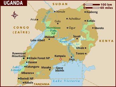
We needed time to get all the preparations ready for an attempt of the Murchison Falls Section of the Victoria Nile which is an 80k section flowing through the heart of Murchison Falls National Park. This involved getting permits, permission, equipment, transportation, and other things. This river has been done 5 times with four of five being assisted by rafts. The first descent was in the 90's. The last descent, by Hendri Coetzee in 2007, was the first self-supported descent of the river. Additionally, he did it by himself.

Appearently, a group of Germans attempted the river around the end of 2007 but only made it 10 or so miles down the river before bailing and had to call the German Embassy to get them out. A ranger at Murchison Falls told us one of their boats was bitten by a croc but we weren't sure of the validity of this - although it is very believable. If someone could clarify this we would appreciate it.

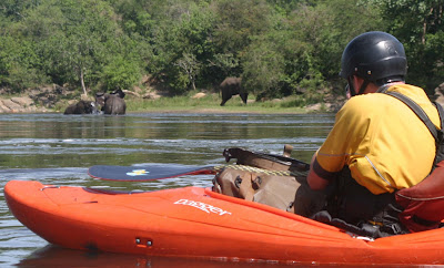
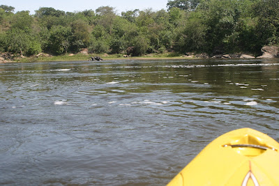
The section itself is through complete wilderness, where humans generally do not belong; where we are a few notches down the food chain. This section of river is home to the highest concentration of hippos in the world. An estimated 20,000 in the 80k stretch. Our group, Rush Sturges, Tyler Bradt, Lane Jacobs and Anton Immler (SWE), saw a guestimate of about 4,000 hippos in the three days. They are in maybe 90 percent of the eddies and at times we were forced to run semi-blind horizon lines because the eddy above the drop would have a pod of hippos in it. Other times, we were forced into channels by process of channel elimination because of hippos. We were constantly tapping our boats trying to alert the hippos of our presence. The hippos would rise and look around at us and generally would keep their distance. Only a few times, when we had to eddy out and scout a rapid, would they approach us. They are appearently responsible for more deaths than any other animal in Africa but had a very different attitude towards us than the crocodiles.

In comparison to the crocodiles, the hippos are tame. The crocodiles are extremley aggressive and territorial. We saw 13 crocodiles and 5 of them chased us. The longest chase was almost two minutes and our arms were going lactic because of sprinting. It is terrifying because crocs can swim maybe almost twice as fast as we can sprint. Luckily, in every chase, we were able to get to a horizon line and enter a rapid at which point the crocs didnt want to follow. In the chases we were constantly looking back at the croc and at the horizon line and seeing which one we would meet first. Every time we would come to a point in the river in which we couldn't see a horizon line we were dreading paddling across it. The safest spots in the river are the rapids.


The fourth chase, was on the second day and the crocodile was maybe about 18 feet long. The scene of this chase is forever ingrained into all of our minds. We were paddling along and came up on a grassy beach by the river with impalas, baboons and warthogs all together on the beach. It was so peaceful and serene. We we looking at it in awe and next thing we know, Lane sees this massive croc swimming very aggressively towards us at a distance of maybe 50 meters and yells to inform the rest of the group. By the time we go to the lip of the horizon he was less than 10 meters away.

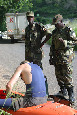
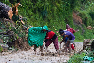
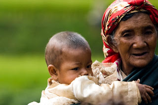
In addition to the wildlife the river-right side, the Gulu district, is the frontier for the Lord's Resistance Army although they are in failing peace talks with the Ugandan government for the last two years. The situation is much better than it was when Tylerwas on the third descent in 2005. At the putin bridge then, there were about 50 soldiers. This time there were only five. This rebel army operates in the border areas between Uganda, Sudan, the Central African Republic and the Democratic Republic of Congo. While we were driving to the putin I picked up an East African Newspaper and read that 300 people had been abducted from the Central African Republic a week earlier and were forced into military training. It seems Joseph Kony, the rebel army's leader, is not serious about peace talks. Appearently, he hasnt even had his negotiator show up to peace talks in the beginning of April 2008.

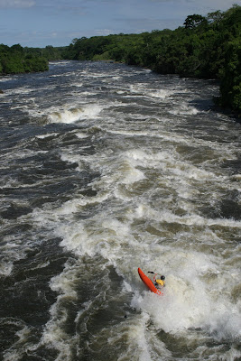
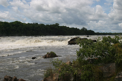
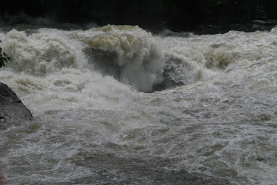
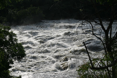
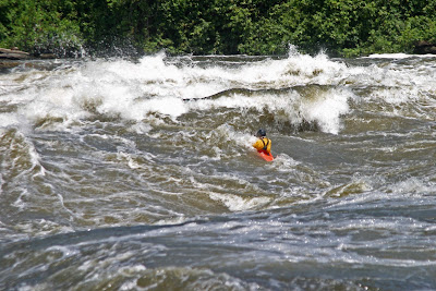
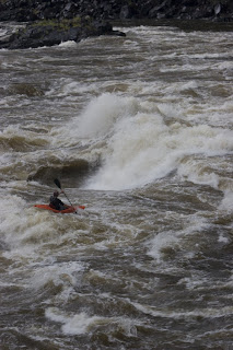
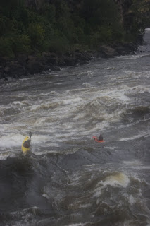
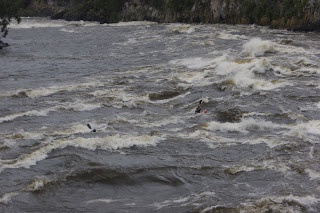
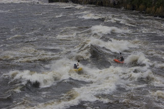
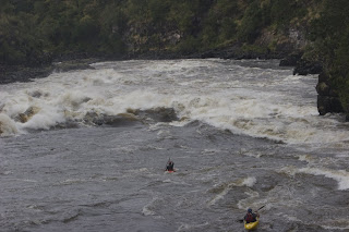
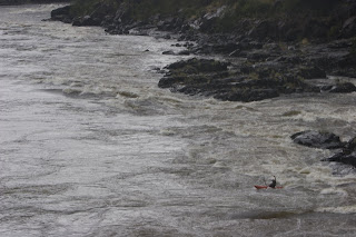
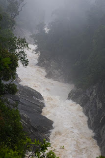
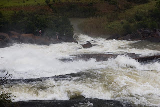
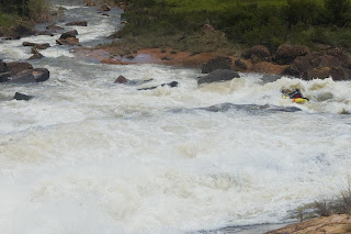
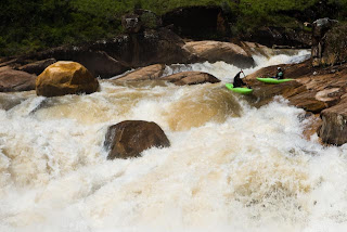
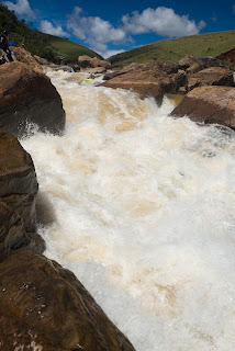
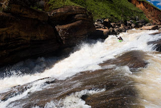
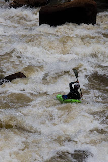
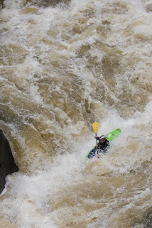
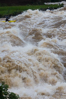
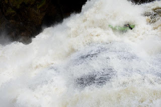
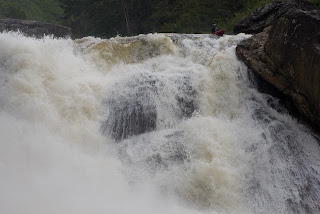
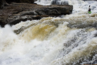
The river itself is high quality Class V, some class VI, big water and pretty continuous the whole way. We had a few portages and a few scouts. It wasn't really possible to take many photos of the rapids because in the event of a swim, which did actually happen on the third day, you would want everyone around to help rescue and fend of wildlife. The river banks were covered in jungle and it was so wide that it wasnt really possible to document the vast majority of the rapids. Here are some photos of our trip. Unfortunatley, I was not able to get as many whitewater shots as I wanted but there are a few. Enjoy.
The team, pangas and paddles in hand, ready at the putin bridge.


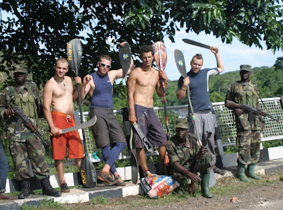
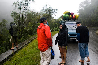
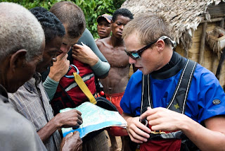
Soldiers at the putin bridge curiously watching what Tyler is packing.

Tyler in the runout of the first rapid, directly under the bridge.


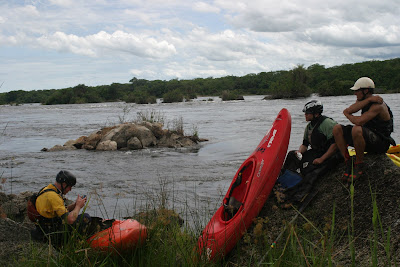
Lunch, Day 1, shortly after the first croc chase.


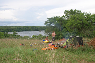
Camp on the first night. We heard hippos throughout the night.

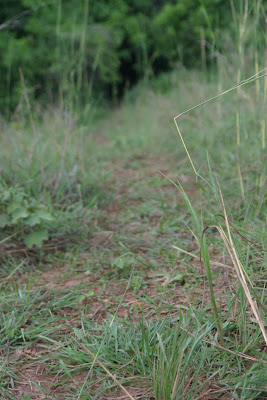
One of the many hippo trails going into the bush and down to the river which are everywhere on the river. We used these to scout, portage, and camp.


Scouting a channel from above on the left side above the major rapid/portage, "Go Right". It looked like a clean shot through a green window but ended up being a HUGE 13 foot green face. We didnt think anyone had run this channel yet but maybe???

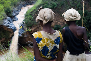
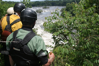
This is us scouting a channel on the river left side. Classic Africa bush full of all the scary beasts. 
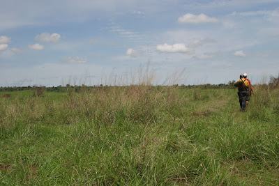
Panorama of Rush at "Go Left", right before Lane came within 3 feet of a croc trying to scout. 
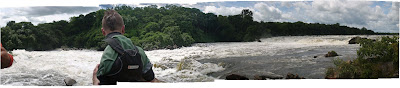
The entrance to "Go Left"


Tyler and Anton working out our line down "Go Left".

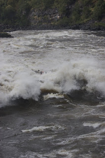
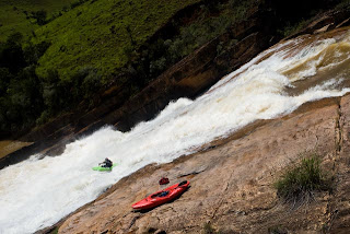
This is why you go left at "Go Left". Hard to get a size perspective from this photo but this crashing wave is about 20 feet high or so and goes straight into a pool full of hippos and undoubtedly crocs.

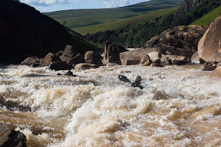
The view from camp two which is of the rapid "Vidiot". This was one of the bigger rapids we ran and was about one kilometer long.

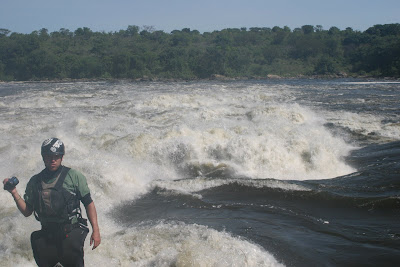
Rush scouting the "Matrix". We had do do some hippo dodging to get into the eddy to scout.


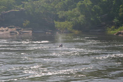
One of the hippos, rising and blowing mist, we had to dodge to scout the matrix. These guys were not happy and wanted us outta there.


Panorama of the "Matrix". The big eddy on the right - same as photo above - was the one with pod of hippos.

Tyler checking out some elephants on day three. The momma was washing the baby in the river with the other one eating leaves out of the trees.

Same elephants but view is from lane's boat.


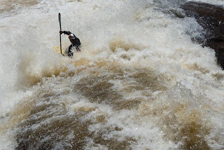
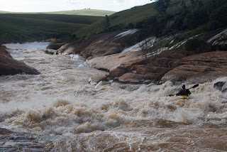
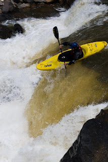
Tyler in a random rapid on day three.


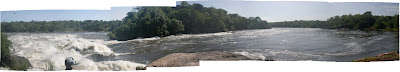
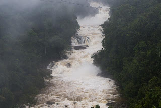
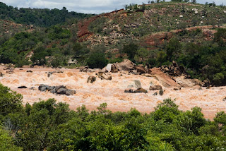
First part of the very impressive Murchison Falls.


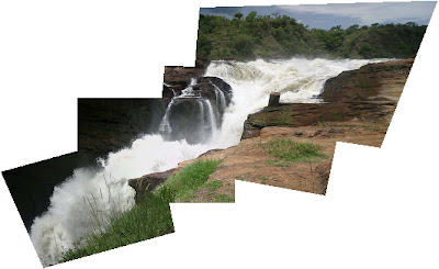
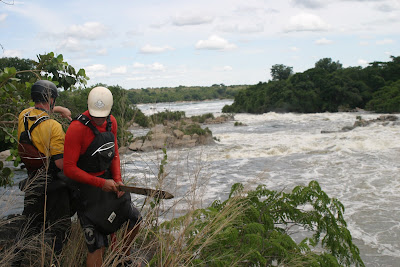
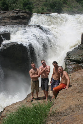
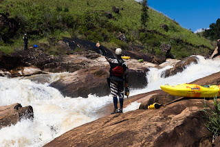
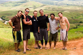
The team stoked to be at Murchison Falls after three long days.

Saturday, March 15, 2008

Zambezi in Flood

***All Photos Copyright Rita Riewerts***
**************************************
After regrouping in SA we made the two day drive up through Botswana to Livingstone, Zambia, home of Victoria Falls and the infamous Zambezi River. We had no idea whether the river was going to be too high or not but word of flooding in the headwaters made us all a bit skeptical. Upon arriving we immediatley went on a 'booze cruise', which is a two story pontoon boat that takes tourists upriver from Vic Falls to see hippos and crocs. After a night of good humour and terrorizing tourists the boys chatted with Tony Barnett, a Zambezi Legend based out of Livingstone since 1995, about the possibility of running the river.

Turns out the river is near the height of its peak. It is 120 meters (not a typo) above the level they raft it at. It is an entirely different river and a raft would be suicidal at these levels. The spray from Vic falls rises above the lip for probably 500 meters. Since last doing it near these levels in the late 90's with Alex Nicks and a few others, Tonys decribed the rapids on pieces of paper and made the river sound doable. The holes were not as much of an issue as were the 4 meter high boils, terminal eddies and the 2 meter deep whirlpools. Swimming is not an option.

So the decision was made and Tyler, Rush and Lane put in. Tyler had done it twice at low levels and it would be Rush and Lane's first trip down the river. After stuffing our laps with rafting PFD's to avoid a skirt implosion we spent the entire day trembling and terrified. Completely disappearing in whirlpools and seams was common. Tyler nearly got washed into 7 and 9 because the eddyfence was absolutley massive. We just tried to stay in the main flow the whole time.

After making it down the river we were happy to be off. However, we felt this river needed needed to be documented and after discovering the lines we felt we could run in much more control. So the decision was made to come back the next day with a chopper and document the run at one of the highest flows ever run. Unfortunately, heavy thunderstorms rolled in as soon as the chopper came in the canyon. It added an extra element to the run. Ian, Lane, Tyler and Rush all made the trip and here are some photos from their trip.

Check them out...

Victoria Falls with the mist rising to an insane height in the air

The falls has been receding along this fault line which has produced this very unique geological formation

Ian and Rush entering number 4

Looking back up number 4

Ian and Rush in the seam between 10 foot boils. This is the entrance to number 5


Ian and Rush hanging on in number 6
Tyler in the runout of Rapid #6

Tyler in the lead with Lane airing out in one of the massive and irregular compression waves. Right below rapid #7.5

Rapid 8 and 9 is one rapid at this level. Here is Lane and Tyler halfway in between, trying to stay in the main flow. On the first day, Tyler barely made the eddy on the left side almost going in to #9 blind. On the second day Ian was caught in a massive whirlpool sucking him down and into the main flow and was forced to run #9 completley blind. The eddy is extremley hard to catch.

Tyler and Lane getting closer and closer to the crux of the run, number 9

Looking down into the biggest rapid either of them has ever run - number 9. The move is right between two building sized holes.

Tyler charging out the backside of number 9 with Lane still somewhere in the maw. Tyler, Lane and Ian were all pretty much sucked through the wave when they hit the irregular funky boil.

Tyler past the last rapid and on top of the world.


As for now we are preparing for our next mission which is to the Eastern Highlands of economically devastaed Zimbabwe. We will carry food and fuel for ten days in an attempt to paddle two rivers - the Gairesi and Pungwe. The Gairesi forms the border with Mozambique and the Pungwe is just south of the Gairesi. With elections coming on March 28th, the trip should be very interesting so keep checking back...

Saturday, March 8, 2008

Mada Wrap-up

***All photos copyright Pat Camblin***
Visit: www.triberiders.ca for more...
************************************
Cyclone Ivan hit Madagascar after only a week of us being in the country. Very intense rain, wind, and mudslides left many of the roads and train tracks in the southern region of the country unpassable. The rivers flooded to ten times their normal high flow. The last estimate our group heard was that the death toll in Mada from the storm was at 150 people. The storm washed away bridges, entire towns, and caused many mudslides and downed trees. After spending almost a week south of Antananarivo and concluding floods and mudslides shut off most of the rivers we decided to head north. Here are a few shots of the rivers we had hoped to get on:

700 fpm at floodstage...no takers needless to say

Another river in the southern region we were hoping to get on.
Every landslide we saw was being clear soley by manual labor. The malagasys are very tough needless to say.

The crew, standing in the rain, attempting to scout another flooded river.
Yes, its a river. And yes, we put on. This was the Mania River at a ridiculous level.

Traditional Malagasy houses with terraced rice patties all around. This was taken a week after the cyclone.

Undoubtedly, heading north was a great decision. It was a bit dryer climate here and searingly hot in the town we based out of for a few days. The mosquitos and thunderstorms were very heavy. The northern part of Madagascar is much more undeveloped and impoverished than the southern areas we had explored.

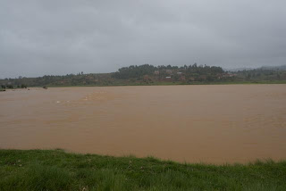
The first river we did flows into the Betsiboka River which is one of Mada's largest. It was had some sweet rapids but with the highlight was the first crocodile encounter our group had seen of our trip. The incident turned out to go something like this:

Floating down a flat, meandering stretch of river....

Ian: Do you think there are croc's on this river?

Capo: No way man, we are way too high in the mountains...

Lane: Yeah, I dont think there is any way they can make it above the slides on the lower part of the river....

Ironically, no less than 30 seconds later we come around a bend, and a 9 foot croc is sunbathing on the rocks. It immediatley sees us, opens its mouth and snaps at us and darts in the water directley towards us. It was only fitting that we see our first croc immediatley after ruling it out.

All of us freaking out, Pat yells: Croc!!

We panic, backpaddle and then decide to forward paddle and get outta there as fast as possible. We make it 500 meters down the river only to look upstream and see Tyler eating food in his kayak with his sprayskirt off, legs dangling in the water, and just lazily floating along.

Since this incident we have seen about 10 crocs and have learned that they are more curious than aggresive and go out of there way to hide from you. The next day we headed towards the Manankazo in hopes of finding a some bedrock slides, which we did.

Manankazo River:

The Manankazo is in north central Madagascar and is a tributary to the Ikopa River. We did about a 65 kilometer section which turned out to be one of the most amazing sections of river any of us had ever done. It was full of big slides and rapids for three days. After a straight week of rain previous to the descent we were feeling the strain and we luckly ended up having three sunny days on the best first descent any of us had done. Here is just a sample of the hundreds of rapids...

Day 1

Lane on one of the slides right at the beginning.
Look closley and you can see Patrick's paddle at the bottom of this beastly slide.
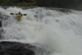
Garcia flying down another amazing 70 ft slide. 
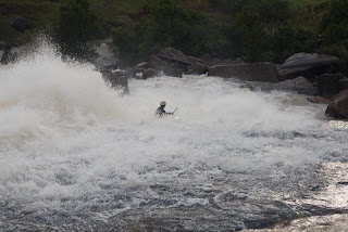
Same slide from above. We camped right here and called it a day.
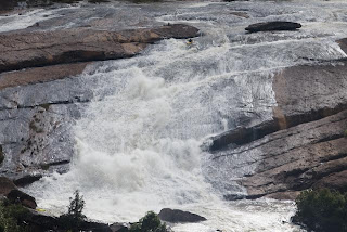
Day 2: the second day was very long - on the water from 8am to 6pm

Lane getting ready to bust over a big hole in a two part drop. The first drop of the day.

Ian at the runnout of the second part, same drop. This was a biggun' and keep an eye out for the upcoming movie as we got some sweet shots of it and photos dont do justice.

Tyler probing yet another amazing 40 foot slide with a hole at the bottom that was absolutley insane. Backed up by a ledged, if you went in there you arent coming out unless its holding on to a rope.

Rush on the same drop. Notice the heinous undercut on river left, making the line even tighter.

Patrick at the first point in which the river really started to drop. this was a sweet 20 footer - it marked the beginning of about a 5k crux section of the run.
Lane getting the thumbs up from Garcia. Getting ready to drop in on a long rapid with slides and falls.


Tyler, further down the same rapid.
Ian firing up a big rapid, much like 'trepidation' of Fantasy Falls in Cali.

Tyler running a rapid with a big hole we named 'gravey train'
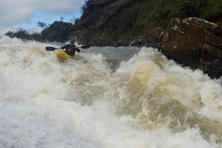
Lane fired up at finding a sweet 150-200 foot slide which would have been totally runnable except for the sieve pile right below it.
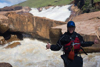
Rush sending the clean 30 footer right below it.

Ian and Lane navigating some complex boulder gardens towards the end of the day.

Lane on the last rapid/slide of the day. This one was very long and ended at the pool at the very furthest point you can see in the photo.


Day 3


Tyler in some pushy boulder gardens at the beginning of day 3 
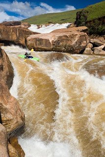
Rush in a rapid named 'mini wasson's' from the rapid on the Stikine. Just downstream is a monstrous beater hole that rush smoothly avoided.

Rush in a big diagnal pourover hole.

Lane, Tyler, Ian, Pat, Capo, and Rush, with the Manankozo behind us, stoked to be off of 3 amazing days of whitewater.
Ikopa River:

This river was documented in the YGP film, "Dynasty". Rush, Tyler and Brad first descented this section in August of 2004, which is in the dry season. Coming back to this river in the height of the wet season, we were not sure how it would be. When we got to the Putin we knew it was roostin' high - maybe 200,000 cfs. The entire run consists of about 8 distinct drops all which have a significant amount of gradient. We ended up skirting everything in side channels but here is a photo of a side channel of 'heaven and hell', a drop documented in "New Reign" at about 10x the flow. It scared the hell out of everyone and we were happy to make it down with no problems other than: Rush getting worrked in a hole above a class VI and Lane throwing ends in a Nomad 8.5 while trying to make a must make ferry above another class VI. It was over 100 degrees f and it made it difficult to even paddle without losing your breath.

Just a side channel.
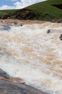
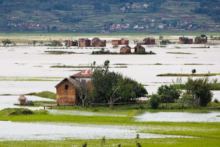
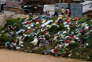
Next we headed down south to the Onive River to do a road side section. It was a great fast and pushy roadside run. We ended up doing a few runs on this with the locals running along the road the entire time.

Onive River:

Pat and Tyler in a rowdy section

Lane and Ian moving as fast as possible to avoid a beatdown.


After the Onive we headed back to Antananarivo to eat some quality food and enjoy the local nightlife.

With a week left in the country we made plans to head out on a final first descent. Choosing to head east and explore a new region of the country we decided to paddle the Laroka based simply off of promising looking gradient lines and road to road access.


The crew was amazed by the incredible character of this river as it dropped to sea level. Having randomly chosen the river from the map it went to show the potential of Madagascar as a paddling destination. We started on a steep tributary with a couple 30 footers and some great slides. It then became the the Laroka proper and turned into some great bigwater class 4/5. In between the rapids locals would pole their bamboo rafts across the river, amazed at the brightly colored spectecles.


Lane boofing the second meaty hole of a sweet triple drop on the Laroka.

Tyler rallying a burly center line the first 30 footer.


Rush on a sweet 2 tiered 30 footer.


Tyler in a sweet slide section.

Ian and Lane in an extremley rural village on the Laroka River that probably has never seen white people trying to communicate: "Where the hell are we?"
We wrapped up our time in Mada in the small town of Vatomandry, on the east coast of Mada. We had an entire beachfront bungalow resort to ourselves and feasted on some amazing seafood, celebrated Rita's birthday, and spent the last few days on the beach bodysurfing, playing poker and chillin'.

Madagascar is an amazing destination unlike any other place on earth. It is hardly Africa as it has been evolving by itself for 165 million years. The geology and amount of precipitation makes it an amazing paddling destination. The people are a bit reserved but very friendly and the food is great. We are all vowing to return as we have specific rivers we are aiming to do on our return trip.


Kids happy to see what we were up to.


Old lady with a baby.

People in Tana drying their clothes after washing them in the Ikopa river, which flows through the capital to the north. 
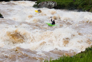
Missing Mada already...

In our month in Mada we paddled the Lily (upper, middle, lower), the Mazy, the Upper Mania, the Onive, the Amboahatimony, the Manakozo (3days), the Ikopa, the Mamakomita, and the Maravezo into the Laroka (2days)...

As of now we are back in South Africa and we are leaving for the Zambezi to check it out at high - possibly too high - flows. Then our goal is to do two rivers in the eastern highlands of Zimbabwe.